 Skip to content
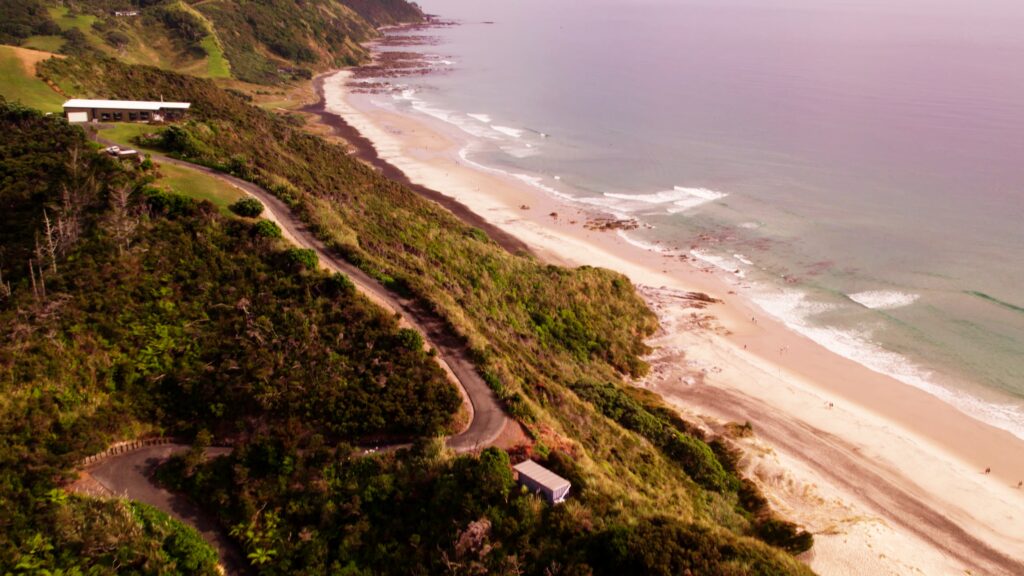
Mangawhai Heads sits at the edge of the Northland coastline, where the Tasman Sea pushes against long stretches of sand, estuary channels and exposed limestone cliffs. It is a place that feels open and coastal in the truest sense — wind, tide, light and rock all working together. Among the various walks in the area, the Mangawhai Cliffs Walkway Loop stands out as the most visually dramatic.
This is not a forest walk or a shaded trail. It is a raw coastal loop that follows the cliff tops before descending to the beach and returning along the shoreline. It is also tide dependent. The full loop can only be completed at low tide, when the beach section is safely passable. Outside of those windows, you must return the way you came.
The walkway suits a half-day visit and is ideal for those wanting expansive coastal views without committing to a multi-hour hike. It is achievable for most reasonably fit walkers, but conditions can change quickly depending on wind, tide and weather. Planning matters here.
Explore more of New Zealand Here
For latest news and updates on New Zealand Weather click here

YouTube Video of Mangawhai
Mangawhai Heads – Navigate our page below
Quick Facts
What to Bring
Map
How to get there
The Trail / The Hike
Things to Do
Facilities
Tidal Strategy
Safety Considerations
Geology Notes
Historical Information & Development
FAQ
Mangawhai Heads Quick Facts
Difficulty Rating – Moderate
Distance (round trip) – Approx. 5–6 km loop
Net Elevation Change – Approx. 120 m
Time Needed – 1.5 to 2.5 hours
Season – Year round (weather dependent)
Dog Friendly – Yes (on leash in some sections; check local rules)
Est. Driving Time from Vancouver – Not applicable (New Zealand location)
Camping – No camping on cliffs; nearby holiday parks available
Wheelchair Accessible – NO
What to Bring
Water – Sun protection – Wind layer – Good walking shoes – Tide timetable – Phone with map – Snacks
This walk is fully exposed to the elements. There is very little shade once you leave the car park, and wind can be stronger along the cliff tops than in town. Proper footwear is important as sections of the track are uneven, sandy or rocky. The most critical item is awareness of the tide timetable. The beach section is only safely accessible at low tide, and the window is limited. Plan your start time accordingly so YOU are not forced to turn back unexpectedly.
Map of Mangawhai Heads


The map helps identify the cliff-top path, descent point to the beach, and the shoreline return section. It is particularly useful for understanding where the loop reconnects near the Mangawhai Heads Surf Beach car park.
How to get to Mangawhai Heads

Mangawhai Heads is located in Northland, approximately 1 hour 45 minutes north of Auckland by car. From Auckland, follow State Highway 1 north before turning east toward Mangawhai via Mangawhai Road. The drive is sealed the entire way and suitable for all vehicles.
Once in Mangawhai Heads township, continue toward the surf beach. The Mangawhai Cliffs Walkway begins near the Mangawhai Heads Surf Beach car park, which is clearly signposted. Parking is free but can fill quickly during summer weekends and public holidays.
There is no dedicated public transport servicing the trailhead directly. Visitors without a vehicle would need to arrange private transport from Auckland or nearby towns.
The track is accessible year round, but strong winds, heavy rain or king tides can impact safety. After prolonged rain, some sections of the trail can be muddy or slightly eroded. Always check tide times before departing. The loop should only be attempted when the beach section is safely exposed at low tide.
The Trail / The Hike


The trail begins from the edge of the Mangawhai Heads Surf Beach car park, where a well-formed path immediately starts climbing. The opening section feels exposed and coastal, with low vegetation and wide ocean views appearing quickly behind you. Within minutes, the elevation gain is noticeable but steady.
As you reach the cliff tops, the views begin to dominate the experience. Limestone formations rise sharply from the water below, and the coastline stretches north and south in uninterrupted lines. The path here is narrow in places but clearly defined. Wooden steps and formed sections assist with steeper inclines.
Midway through the loop, the terrain undulates along the ridge. Small dips and rises create a rhythm to the walk. There are several natural stopping points where walkers pause to photograph the coastline or watch waves striking the rock platforms below. On clear days, visibility extends far along the Northland coast.
The descent toward the beach is the most technical part of the walk. It involves a series of steps and slightly steeper sections. Footing remains manageable but requires attention, particularly in windy conditions.
Once you reach the beach at low tide, the environment changes completely. The cliffs now tower behind you, and the return section follows the hard-packed sand. This stretch is flat and far less strenuous than the cliff section. The loop closes as you approach the main surf beach area near the car park.
Most walkers complete the full loop in around two hours at a steady pace, allowing time for stops and photos.
Things to Do at Mangawhai Heads

The primary reason to complete the Mangawhai Cliffs Walkway Loop is the coastal perspective. Photography is particularly rewarding here, especially during early morning or late afternoon when the cliffs cast stronger shadows and the sea reflects softer light.
Beach walking at low tide is also a highlight. The exposed sand and rock platforms create space to slow down and explore. Many walkers spend additional time on the shoreline before closing the loop.
During summer, visitors often combine the cliff walk with swimming at Mangawhai Heads Surf Beach. Conditions vary depending on swell and wind, so observe lifeguard advice if present.
Seasonally, the experience shifts slightly. Summer brings longer daylight hours and busier tracks. Winter offers fewer crowds and a more dramatic sea state, but stronger winds are common.
Facilities at Mangawhai Heads

Facilities are centred around the Mangawhai Heads Surf Beach car park. Public toilets are available near the main beach access. There are no toilets along the cliff track itself.
There is no potable water provided along the walkway, so visitors must carry their own. Picnic tables are available near the beach car park, but not on the cliff tops.
Cell service is generally available, though reception may fluctuate along certain cliff sections. There are no shelters or covered areas on the track.
Leave-no-trace principles apply. The cliffs are a sensitive coastal environment subject to erosion. Stay on marked paths, avoid shortcutting switchbacks, and carry out all rubbish.
Tide Strategy

The Mangawhai Cliffs Walkway Loop is tide dependent. The cliff section can be completed at any time, but the beach return section is only safely accessible at low tide. Planning around this is essential.
The safest strategy is to begin the walk approximately 60–90 minutes before low tide. This allows enough time to reach the descent point without feeling rushed and ensures the beach is fully exposed when you arrive. Starting too early may mean waiting on the sand for the tide to recede. Starting too late risks the water cutting off sections of the shoreline.
The return section along the beach involves passing beneath sections of cliff and rock platforms that become submerged quickly as the tide rises. There are no alternative inland bypass tracks once you have descended to the sand.
Before departing:
- Check the Mangawhai Heads tide timetable for the specific day.
- Confirm the height of the low tide (lower tides provide wider beach access).
- Avoid attempting the loop during king tides or strong onshore swell conditions.
- Factor in wind direction, as strong onshore winds can push waves higher up the beach than predicted.
If unsure, complete the cliff section as an out-and-back walk instead of committing to the full loop. The views from the ridge provide most of the visual reward without relying on beach access.
Tide awareness is not optional here — it is part of the walk itself.
Safety Considerations

While the Mangawhai Cliffs Walkway is not technically difficult, it is an exposed coastal track. Conditions change quickly and require basic awareness.
Cliff edges are unguarded in most sections. Stay well back from edges, especially in strong winds. Gusts can be sudden and stronger on the ridge than at ground level near the car park.
The descent to the beach includes steps and uneven sections that may be slippery after rain. Good footwear significantly reduces risk here.
Sun exposure is another factor. There is very little shade for the majority of the loop. In summer, temperatures on the cliff tops can feel higher than forecast due to reflection from rock and sand. Carry water even though the walk is relatively short.
Weather changes can also move in quickly from the Tasman Sea. Low cloud, strong wind, or rain can reduce visibility and make footing less secure.
Key safety points to keep in mind:
- Check tide times before committing to the loop.
- Wear stable footwear with grip.
- Carry water and sun protection.
- Maintain safe distance from cliff edges.
- Supervise children closely.
- Avoid the descent in heavy rain or high winds.
- Do not shortcut erosion control fencing or track boundaries.
This is a walk where awareness matters more than fitness. The environment is open and powerful. Respect it and the experience remains straightforward.
Geology Notes
The cliffs at Mangawhai Heads are composed primarily of limestone and coastal sedimentary formations shaped by marine erosion over time. The layered rock visible from the track reflects millions of years of deposition, uplift and exposure to wave action.
These limestone formations were originally created from compressed marine sediments and shell fragments. Over time, tectonic activity raised sections of the seabed, forming the elevated cliffs seen today.
The jagged rock platforms below the track are the result of constant wave erosion. At low tide, these platforms become visible, revealing uneven surfaces carved by water movement and salt weathering.
The pale colouring of the cliffs contrasts sharply with the deep blues and greens of the Tasman Sea. This contrast is particularly noticeable in strong sunlight, which enhances texture and shadow across the rock faces.
Coastal vegetation has adapted to the limestone environment. Low shrubs and hardy grasses dominate the cliff tops, stabilising soil and slowing erosion. The track infrastructure — steps and formed pathways — exists specifically to protect this fragile terrain.
Understanding the geology adds context to the walk. The cliffs are not simply scenic features; they are the visible result of long-term coastal processes that continue shaping the headland today.
Historical Information & Development
The Mangawhai region has long been significant to Māori communities, who utilised the surrounding coastal and estuary environments for fishing and seasonal settlement. The harbour provided access to kai moana and safe anchorage.
European settlement in the 19th century saw Mangawhai develop as a small coastal community focused on agriculture and later holiday tourism. Over time, the natural beauty of the cliffs and beaches became a defining feature of the area.
The Mangawhai Cliffs Walkway itself has been progressively formed and maintained to allow public access while minimising erosion. Boardwalk sections and defined tracks reduce environmental impact. Development has remained limited to preserve the fragile limestone formations and coastal vegetation.
Today, the walkway balances recreation with conservation. It remains one of the most recognisable short coastal loops in Northland without extensive infrastructure or commercial development along the track itself.
FAQ
How long does the Mangawhai Cliffs Walkway Loop take?
Most walkers complete the loop in 1.5 to 2.5 hours, depending on pace and photo stops.
How hard is the walk?
It is rated moderate. The elevation changes are manageable but consistent, and the descent to the beach requires care.
Can you do the loop at high tide?
No. The beach return section is only safely accessible at low tide. Check tide times before starting.
Is it family friendly?
Older children who are comfortable on uneven terrain should manage well. The cliff edges require supervision at all times.
Are dogs allowed?
Dogs are generally permitted but may need to be on leash in certain sections. Check local council signage before visiting.
Is it worth doing?
If YOU enjoy exposed coastal views, limestone cliffs and varied terrain within a short distance, the loop offers strong visual reward for moderate effort.