 Skip to content

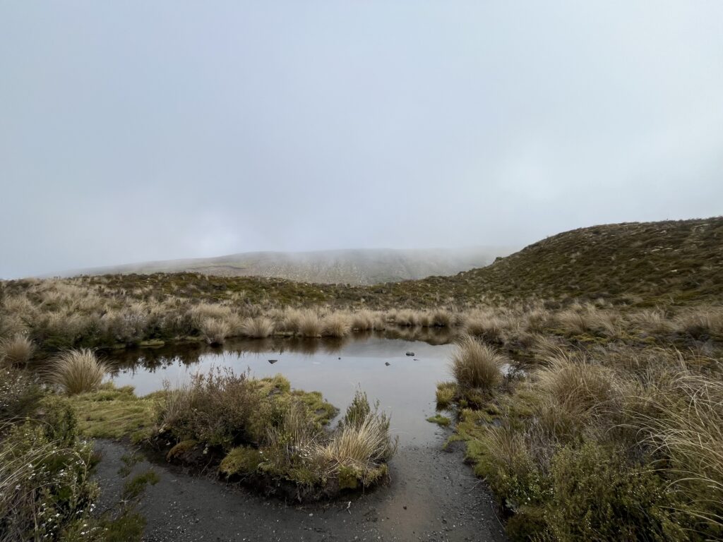
There are hikes, and then there are experiences that reframe what a hike can be. The Tongariro Alpine Crossing sits firmly in the second category. This is not a forest trail or a coastal walk. It is a crossing of an active volcanic landscape at altitude, where the terrain shifts from ancient lava flows to vivid crater lakes to loose scoria descents, all within a single day. The Tongariro Alpine Crossing complete guide you are reading now exists for one reason: this walk deserves proper preparation, and a lot of people show up underprepared.
Done well, it is one of those days that stays with you for a long time. Done carelessly, it can go wrong in ways that are difficult to reverse.
This guide covers everything. The route, the terrain, the logistics, what to bring, how to book, and what to actually expect at every stage of the track.
The Essentials at a Glance
Before getting into the detail, here is the core information.
Distance: 19.4 km one-way
Duration: 6 to 8 hours (8 to 9 hours in winter)
Elevation gain: Approximately 800 metres
Highest point: Red Crater at 1,886 metres
Start point: Mangatepopo Road End (1,120 metres)
End point: Ketetahi Road End (760 metres)
Track type: One-way, point to point
Difficulty: Demanding. A high level of fitness is required
Booking: Required via DOC (free, no cap on numbers)
Shuttle: Strongly recommended. Four-hour parking limits apply at both ends during the main season
Best season: November to April for most hikers
What Makes the Tongariro Alpine Crossing Different
Most famous hikes earn their reputation through one thing: a view, a summit, a waterfall. The Tongariro Alpine Crossing earns it through everything happening at once. You start in a wide valley, climb through a volcanic landscape that feels genuinely otherworldly, reach a crater rim with views stretching to the horizon, and descend past lakes so vivid their colour seems digitally enhanced.
The track passes through the volcanic terrain of Mount Tongariro, an active multi-cratered volcano, with Mount Ngauruhoe rising to the south as a constant reference point throughout the walk. This is a UNESCO Dual World Heritage site, recognised both for its geological significance and its deep cultural importance to the Maori people, particularly Ngati Tuwharetoa, for whom this mountain is an ancestor, not a landmark.
That context matters. The mountain is not just a scenic backdrop. It carries meaning, and walking across it respectfully is part of the experience.
A Note on the 2025 Fire
In November 2025, a wildfire swept through nearly 3,000 hectares of Tongariro National Park. The fire affected vegetation in the Mangatepopo area, and parts of the landscape along the early sections of the track are now blackened. The crossing itself reopened on 17 November 2025, and the main volcanic features, including Red Crater, the Emerald Lakes, and Blue Lake, were unaffected. The track is open and safe. The Mangatepopo Track, which forms part of the Tongariro Northern Circuit, remains closed separately.
If you are planning the crossing now, the experience remains intact. The landscape has simply changed in character in certain sections. Always check the DOC website for the latest conditions before your visit.
The Route: Section by Section
Understanding the route before you walk it makes a significant difference. There are no major surprises if you know what is coming.
Section One: Mangatepopo Valley to South Crater

The crossing starts gently. The first section follows the flat floor of the Mangatepopo Valley, which is well-formed and boardwalked in wetter areas. Marker poles guide the route clearly. The valley is wide and open, with the volcanic cone of Ngauruhoe visible to the south throughout.
Around 15 minutes from the start, the track to Whakapapa Village branches right. A further five minutes on, a side track leads to Mangatepopo Hut and toilet facilities. If you need them, use them here, as options become limited higher on the track.
After the hut junction, the terrain begins to change. The track climbs steadily toward South Crater via a rocky staircase that gains around 350 metres. This is where the crossing earns its reputation for difficulty. The climb is sustained, the terrain becomes more exposed, and the wind often arrives here. Pace yourself on this section. It is the moment most people realise they underestimated the fitness demand.
South Crater itself is a flat, open expanse that offers a brief respite. The volcanic scale of the landscape becomes clear from here.
Section Two: South Crater to Red Crater

From South Crater, the track climbs again along an exposed ridge toward Red Crater. This is the highest and most dramatic section of the entire crossing. The ridge walk is exposed to wind from both sides, and conditions can shift quickly. The views from the ridge on clear days extend across the Oturere Valley, toward the Rangipo Desert and the Kaimanawa Ranges.
Red Crater sits at 1,886 metres and is the highest point of the crossing. The crater itself is dramatic, the ground coloured in deep reds and oranges from the iron-rich volcanic minerals. Steam vents are active nearby. On a clear day, views from this point can reach Lake Taupo and beyond.
Take your time here. This is a landscape that rewards a moment of stillness.
Section Three: Red Crater Descent to the Emerald Lakes
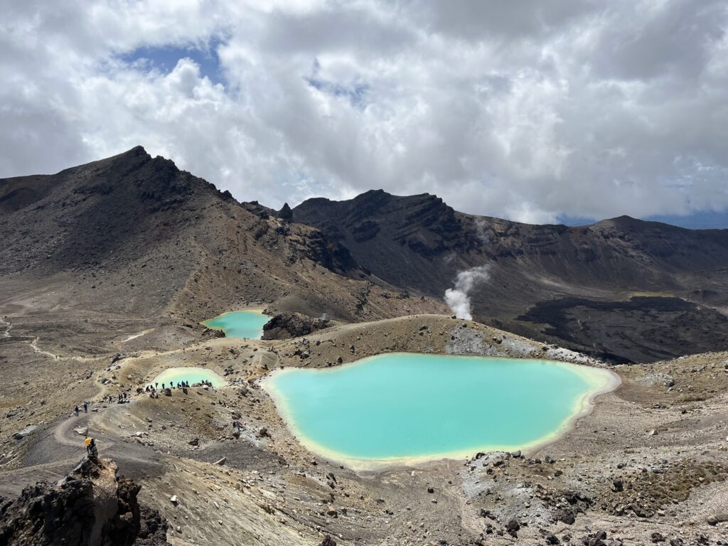
The descent from Red Crater is the section most people remember, and not always fondly. The slope is steep, loose scoria underfoot moves unpredictably, and tired legs after a long climb feel every metre of it. Poles help considerably on this descent. Take small, deliberate steps and do not rush.
At the bottom of the scoria slope sit the Emerald Lakes, the visual centrepiece of the entire crossing. Three crater lakes coloured in vivid turquoise and green from dissolved minerals. The colour is real, not a filter. On a calm, clear day the contrast between the red volcanic ground and the lake surface is unlike anything most people have seen before.
Blue Lake sits just beyond the Emerald Lakes, slightly larger and no less impressive. This lake holds particular spiritual significance for Ngati Tuwharetoa. No swimming, no touching the water, and no sampling. This is observed respectfully.
Section Four: Blue Lake to Ketetahi

From Blue Lake the track descends steadily through alpine vegetation that transitions from volcanic stone to scrubland to native bush as altitude drops. The descent to Ketetahi is long and relentless on tired legs, particularly in the final stretch.
The vegetation becomes denser as you descend, and the landscape shifts from the raw volcanic character of the summit area to something greener and more enclosed. By the time you reach the Ketetahi shelter, most hikers have been walking for five to seven hours.
One thing worth knowing: after the official end of the track at Ketetahi, there is approximately 800 metres to one kilometre of gravel road walking before reaching the car park. Plan for this extra distance in your time and energy budget.
How to Get There and Back

The Shuttle
The crossing is one-way, which means your car is at the wrong end when you finish. A shuttle is the standard solution and is strongly recommended. DOC enforces a four-hour parking limit at Mangatepopo from mid-October through April, making it impractical to leave a vehicle there for the duration of the crossing.
Shuttles depart from several bases including Tongariro National Park Village, Whakapapa Village, and Turangi. The Ketetahi Car Park operates as a private, secure parking option that includes shuttle access to the Mangatepopo start. This is a practical and popular arrangement.
Shuttle times vary by season and operator. Most morning departures run between 6 am and 9 am. Book in advance, particularly in summer. Your shuttle operator will typically monitor the weather forecast and contact you if the service needs to be cancelled or adjusted.
Booking Your DOC Registration
Since October 2023, all hikers must register with the Department of Conservation before walking the track. The registration is free and there is currently no cap on numbers. You need a valid DOC booking reference before you can reserve a shuttle or join a guided walk. From late 2027, a small fee will apply for international visitors, though the crossing remains free for New Zealanders.
Book through the official DOC website at doc.govt.nz.
Guided Tours and Experiences
If you want the logistics managed for you, or if you are walking in shoulder season or winter and want expert guidance, guided options are available. A good guide makes the experience richer, particularly around the cultural significance of the landscape and the finer points of the volcanic features.
You can browse current Tongariro Alpine Crossing tours and guided experiences here:
Tongariro Alpine Crossing guided tours on Viator
For broader Taupo and Tongariro region experiences, including transfers, tours, and day trips:
Taupo tours and experiences on Viator
What to Pack
Gear on the Tongariro Alpine Crossing is not optional comfort. It is the difference between a good day and a serious situation.
Footwear
Proper hiking boots with ankle support are strongly recommended. The scoria descent from Red Crater is steep and loose. The lower sections of the track can be muddy and uneven. Running shoes and casual footwear struggle badly on this terrain. Waterproof boots are ideal given how quickly the weather can change.
Clothing Layers
The temperature at Red Crater can be ten degrees colder than at the carpark. Pack a moisture-wicking base layer, a fleece or insulating mid-layer, and a waterproof and windproof outer shell. No cotton or denim. Those fabrics hold moisture and cool you rapidly when you stop moving.
Food and Water
Pack at least two to three litres of water. There is no reliable water source on the upper track. High-energy food for a full day is essential. You will be walking for six to eight hours and the climb from the valley floor to Red Crater burns through reserves quickly.
Sun Protection
Above the treeline, UV exposure is significant, particularly in summer. Sunscreen, sunglasses, and a hat are not optional items. The volcanic terrain reflects light and the elevation intensifies exposure.
Poles and Extra Gear
Trekking poles make a real difference on the Red Crater descent and on the long Ketetahi drop. A headtorch is worth carrying in case you run long. A fully charged phone and, for winter or early season hiking, a personal locator beacon is recommended.
Key Tips Before You Go
Check the Forecast the Day Before
Alpine weather on the crossing moves fast. Forecasts that look clear three days out can look very different 24 hours before departure. Check MetService mountain forecasts and check with your shuttle operator. If they cancel, the mountain is telling you something worth listening to.
Start Early
An early start serves multiple purposes. You beat the peak crowd on the Red Crater section, you have more buffer time if conditions slow you down, and you are less likely to be racing to finish before dark. Most experienced hikers aim to be on track by 7 am or earlier.
Stay on the Track
The volcanic terrain is fragile. The 2025 fire damaged significant areas of native vegetation that took decades to establish. Cutting corners or leaving the formed path accelerates erosion and causes long-term damage. The track is well-marked. Follow it.
Respect the Cultural Significance
Tongariro is a sacred ancestor to Ngati Tuwharetoa. Blue Lake carries deep spiritual meaning and swimming in or touching the water is strictly prohibited. Approach the landscape with the respect you would give any place that holds that kind of weight for the people it belongs to.
Build in a Backup Day
Weather closures happen. Shuttle operators cancel when conditions are unsafe, and they are experienced at reading this environment. If you have a fixed flight home the morning after your planned crossing date, you are taking a risk. Build in an extra day where possible. The difference between missing the crossing entirely and completing it often comes down to having that flexibility.
Frequently Asked Questions
How hard is the Tongariro Alpine Crossing? Demanding but not technical. You do not need climbing experience. You do need a solid base of fitness, appropriate footwear, and the right gear for alpine conditions. The Red Crater climb and the scoria descent are the two sections that challenge most people.
How long does the Tongariro Alpine Crossing take? Between six and eight hours for most people at a steady pace. Eight to nine hours in shoulder or winter conditions. Starting earlier gives you more buffer.
Do I need to book to walk the Tongariro Alpine Crossing? Yes. A free DOC registration is required for all hikers since October 2023. You need that booking reference before arranging a shuttle. Book at doc.govt.nz.
Can beginners do the Tongariro Alpine Crossing? In summer conditions, yes, if you are reasonably fit and properly equipped. In winter, it is not suitable for beginners without alpine experience and appropriate gear including crampons and an ice axe.
Is the crossing affected by the 2025 fire? The main crossing track is open and safe. The volcanic features are unaffected. Some vegetation in the Mangatepopo area is visibly fire-damaged. The Mangatepopo Track, which is a separate route forming part of the Tongariro Northern Circuit, remains closed. Always check the DOC website before visiting for the latest status.
Can I do the crossing without a shuttle? The logistics make it very difficult. The track is one-way and DOC enforces a four-hour parking limit at both ends during the main season. Unless you have a vehicle drop-off arrangement with another person, a shuttle is the practical solution for the vast majority of hikers.
What if the weather turns bad during the crossing? Know the turnaround point marked on your shuttle operator’s map before you start. If you reach that point and conditions are deteriorating, contact your operator and turn back. Do not push through poor visibility, high wind, or dangerous conditions on the exposed sections.
A Final Word
The Tongariro Alpine Crossing does not need embellishment. The landscape does everything the words are trying to do. What it does need is respect: for the mountain itself, for the people whose ancestor it is, and for the conditions that make it one of the most demanding day walks in the country.
Prepare carefully, book your shuttle, check the forecast, and start early. The Tongariro Alpine Crossing complete experience is waiting on the other side of that planning, and it is worth every step of it.